HTML5 Geolocation API: Getting the best single location

The Geolocation API is built into all modern mobile browsers and it lets you take either a quick, onetime snapshot, or you can get continuous location updates. Using the browser to get your approximate location is very, very cool, but it’s also fraught with many challenges. The vast majority of blog posts on this API talk about what it can do, this blog post focuses on how to best use it and understanding the data provided by the API.

To start things out, let’s take a quick look at a short list of some of the challenges when using the Geolocation API.

Challenge 1. You will not know where the location information is coming from. There’s no way to tell if it’s from the GPS, the cellular provider or the browser vendors location service. If you care about these things then the native Android SDK, for example, gives you a huge amount of control over what they call ‘location providers.’

Challenge 2. You cannot force the app to stay open. This means that the typical user has to keep tapping the app to keep it alive otherwise the screen will go to sleep and minimize your app.

Challenge 3. Speaking about minimizing apps, when the browser is minimized the geolocation capabilities stop working. If you have a requirement for the app to keep working in the background then you’ll need to go native.

Challenge 4. You’ll have very limited control over battery usage. Second only to the screen on your phone or tablet, the current generation of GPS chips are major energy hogs and can suck down your battery very quickly. Since the Geolocation API gives you very little control over how it works you cannot build much efficiency into your apps.

Challenge 5. Most smartphones and tablets use a consumer-grade GPS chip and antenna, and that limits the potential accuracy and precision. On average, the best possible accuracy is typically between 3 and 10 meters, or 10 – 33 feet. This is based on my own extensive experience building GPS-based mobile apps and working with many customers who are also using mobile apps. Under the most ideal scenario, the device will be kept stationary in one location until the desired accuracy number is achieved.

What’s it good for? Okay, you may be wondering what is browser-based geolocation good for? It’s perfect for very simple use cases that don’t require much accuracy. If you need to map manhole covers, or parking spaces, or any other physical things that are close together you’ll need a GPS device with professional-level capabilities.

Here are a few generic examples that I think are ideal for HTML5 Geolocation:

  • Simply getting your approximate location in latitude/longitude and converting it to a physical address.
  • Finding an approximate starting location for searching nearby places or things in a database or for getting one-time driving directions.
  • Determining which zip code, city or State you are in to enable specific features in the app.
  • Getting the approximate location of a decently sized geological feature such as a park, a building, a pond, a parking lot, a driveway, a group of trees, an intersection, etc.

What’s the best way to get a single location? The best way to get a single location is to not use getCurrentPosition() but to use watchPosition() and analyze the data for a minimum set of acceptable values.

Why? Because getCurrentPosition() simply forces the browser to barf up the best available raw, location snapshot right now. It literally forces a location out of the phone. Accuracy values can be wildly inaccurate, especially if the GPS hasn’t warmed up, or if you aren’t near a WiFi with your WiFi turned on, or if your cellular provider can’t get a good triangulation fix on your phone, or it returns a cached value from a different location altogether. There are many, many “what ifs?”

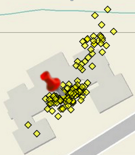
So, I recommend using watchPosition() and firing it off and letting it run until the return values meet some minimum criteria that you set. You need to know that while this is happening the location values returned may cover a fairly wide geographic area…remember our best accuracy values are 10 – 30 meters. Here’s a real-world example of Geolocation API location values that I captured over a 5 minute period while standing stationary in front of a building.

5 minute snapshot

What steps do you recommend? Here are five basic steps to help guide you towards one approach for getting the best location. This is a very simplistic approach and may not be appropriate for all use cases, but I think it’s adequate to demonstrate the basic concepts for working towards determining the best possible location.

Step 1. Immediately reject any values that have accuracy above a certain threshold that you determine. For example, let’s say we’ll reject any values with an accuracy reading greater than 50 meters.

Step 2. Create three arrays, one for accuracy, latitude and longitude. If the accuracy is below your threshold, or in this case < 50 meters, then push the values to the appropriate arrays. You will also need to set a maximize size for the array and create a simple algorithm for adding new values and removing old ones.

The array length could be 10, 20 or even 100 or more entries. Just keep in mind that the longer the array, the longer it will take to fill up and the longer the user will have to wait for the end result.

Step 3. Start calculating the average values for accuracy, latitude and longitude.

Step 4. Start calculating the standard deviation for accuracy, latitude and longitude.

Step 5. If your arrays fill up to the desired length and the average accuracy meets your best-possible criteria, and the standard deviation is acceptable then you can take the average latitude, longitude values as your approximate location.

For an example of this simple algorithm at work visit the following URL on your phone and step outside to get a clear view of the sky: https://esri.github.io/html5-geolocation-tool-js/field-location-template.html. [Updated link: Oct. 27, 2015]

7 tips for safe surfing while traveling

I’ve been asked many times how do I safely use the internet while traveling. Here’s a summary of my notes that will significantly reduce the possibility of having your identity, credit card info or online credentials stolen. None of us are 100% vigilant and fool-proof especially during the haste and confusion of modern day travel. These are all simple suggestions that can provide you with peace-of-mind.

No free Wifi. Avoid free Wifi if at all possible, period. Being cheap can end up costing you a lot. In my humble opinion, the risks of free Wifi when you are traveling simply aren’t worth it. For more details keep reading and I also offer suggestions to protect your online presence if you have to use free Wifi.

Use 3G or 4G.  Instead, I recommend you use your cellular data plan, tethering or buy a cellular hotspot. Generally speaking, 3G and 4G is more secure than Wifi because the equipment to crack it is significantly more expensive and heavily regulated. If you travel to a foreign country you can also buy phones with short term rental contracts, or if your phone uses a SIM card you buy one of those with a data plan. This may cost less and provide a greater amount of data allowance than having your existing provider activate international roaming.

Verify Wifi SSIDs. If you have to use Wifi, have hotel staff or restaurants/coffee shops write down the SSID number of their free Wifi. That way you are sure to log in to the correct network. The fastest way to get virtually compromised is to accidentally log into an increasing number of fake networks specifically designed to steal credentials. If you aren’t an expert in network security, and that’s the vast majority of us, then you may not know this happened until it’s too late.

Use a VPN. Considering using Virtual Private Network or VPN software. Most companies offer these to their business travelers. Consumers can use these as well, and an example of that is proXPN which has both free and paid options: https://www.proxpn.com. A VPN encrypts your traffic and helps to double protect user names, passwords and content. Look for VPNs that protect not just internet traffic but instant messaging and any other software you may be running such as Skype. The proXPN paid version protects all traffic on web clients and mobile devices, where the free version only protects basic internet surfing. Paid versions also typically provide better surfing speeds than free versions.

Use Tor. Check out the Tor browser for general surfing as it provides you with a decent measure of security against criminals snooping your email or online purchases. If it’s legal for the country you are in, consider installing Tor: https://www.torproject.org/. Recent versions work on Android devices, as well. And, Tor can be used along with some VPNs for even greater levels of security. Not every online vendor that you use is practicing 100%, up-to-date perfect security practices.

Verify HTTPS. Make sure your email connections are using HTTPS. Most browsers have indicators or lock symbols that indicate a secure connection, the most important thing to look for is HTTPS in the URL of the website. In some circumstances this may not protect your username and password but it’s better than no encryption. It will help to protect the contents of your email. Without HTTPS everything you send will be in clear text for bad guys to easily read as a road-side billboard.

Use pre-paid credit. Use a pre-paid credit card for any online transactions while your traveling, for example MasterCard offers these. Doing this can help protect your main credit card for emergencies. If you have to pay for something via the internet it’s much safer to use a pre-paid credit card that has a finite amount of money that you can lose.

Last Words

The good news is that new forms of authentication, such as two-step authentication, are being increasingly used and definitely help reduce the possibility of account hijacking. Having your credit card number stolen while surfing, however, poses immediate challenges unless you happen to carry around a ton of cash with you all the time. Employing the methods above while you are away from home easily provide an extra layer of security to make sure you get home safely and on time with as little disruption and stress as possible.

HTML5 Geolocation API – how accurate is it, really?

If you are a developer building applications that require location information then you need to know what is really possible with the HTML5 Geolocation API and not a bunch of hype. The blog post attempts to give you some insight into how it works with desktop and mobile browsers as well as having a greater appreciation for what is and what isn’t possible. I’m going to show you that accuracy depends on many factors, some of which are beyond your control, and at best the location information returned by the API is just an approximation.

[Editors note: as of June 29th, 2013 Part 2 of this post is now available]

Most common use case. For the most part, HTML5 Geolocation works just fine in dense urban areas when you are stationary with your laptop or smartphone Wifi turned on. This is the use case most commonly cited when questions are asked about accuracy. This makes sense because urban areas have many public and private Wifi routers and cell phone towers are typically closer together. As you’ll see, HTML5 uses these and other methods to pinpoint your location. However, it’s not always that simple and below are some other use cases that you should take into consideration.  

How does the API work? Depending on which browser you are using, the HTML5 Geolocation API approximates location based on a number of factors including your public IP address, cell tower IDs, GPS information, a list of Wifi access points, signal strengths and MAC IDs (Wifi and/or Bluetooth). It then passes that information to a Location Service usually via an HTTPS request which attempts to correlate your location from a variety of databases that include Wifi access point locations both public and private, as well as Cell Tower and IP address locations. An approximate location is then returned to your code via a JavaScript callback.

As an example to show you what type of information is sent to a Location Service, I did some basic testing with Firefox 11. Firefox uses Google’s Location Service. On a related note, as far as I can tell with Firefox 11 it isn’t passing cookies any more where in Firefox 3.6 they use to pass a user ID token.

Firefox 11 browser sends queries to https://maps.googleapis.com/maps/api/browserlocation/json? The example results have been obfuscated, but by looking at it you should get the idea of what content is being sent:

GET /maps/api/browserlocation/json?browser=firefox&sensor=true&wifi=mac:01-24-7c-bc-51-46%7Cssid:3x2x%7Css:-37&wifi=mac:09-86-3b-31-97-b2%7Cssid:belkin.7b2%7Css:-47&wifi=mac:28-cf-da-ba-be-13%7Cssid:HERESIARCH%20NETWORK%7Css:-49&wifi=mac:2b-cf-da-ba-be-10%7Cssid: ARCH%20GUESTS%7Css:-52&wifi=mac:08-56-3b-2b-e1-a8%7Cssid:belkin.1a8%7Css:-59&wifi=mac:02-1e-64-fd-df-67%7Cssid:Brown%20Cow%7Css:-59&wifi=mac:2a-cf-df-ba-be-10%7Cssid: ARCH%20GUESTS%7Css:-59 HTTP/1.1

Which location service do browsers use?

Not all Geolocation services are the same, and they certainly don’t all use the same algorithms and exact same databases. Because of this the results typically vary across browsers that use different Geolocation services.

Here’s my best attempt to document which Geolocation service each of the major browsers are using. I haven’t done any definitive testing however I do know from experience that different browsers and even different laptops for smartphones will return different locations when tested from the exact same location. Some location services are better in some cities and others are better in other cities. I haven’t come across a definitive list, most likely because the information is constantly being updated. I’ve included a link to a demo application at the bottom of this blog where I encourage you to also test the API against different browsers.

  • Chrome uses Google Location Services.
  • Firefox on Windows uses Google Location Services.
  • Firefox on Linux uses GPSD – https://catb.org/gpsd/. I’m not sure if this includes Android. I haven’t had a chance to test it yet.
  • Internet Explorer 9+ uses the Microsoft Location Service.
  • Safari on iOS uses Apple Location Services for iPhone OS 3.2+.
  • I’m not sure what Safari on Windows uses. With all the public distrust between Apple and Google, I wouldn’t be surprised if Safari on Windows also uses Apple’s Location Service, but I haven’t found any documentation to verify this and I haven’t tested it.
  • Opera uses Google Location Services. On a related note, I’ve also noticed that mobile Opera on Android accesses the GPS. This is something to consider from a battery usage standpoint.

Not all browsers support HTML5. It’s important to note that not all browsers support the HTML5 Geolocation API, for example Internet Explorer 8. The HTML5 Geolocation API is built into the browser and is accessible using JavaScript methods that access the navigator object. In order to work it requires HTML5 support in the browser. You can research whether or not a particular browser supports Geolocation by going here: https://mobilehtml5.org/ or https://caniuse.com.

Additionally, if a user has disabled JavaScript for some reason, then your Geolocation app won’t work in their browser. JavaScript code is required to access the API.

HTML5 Geolocation requires an internet connection. If you lose your internet connection then you won’t be able to access the Location Service. With no internet connection most browsers will not return a location. Sometimes you can access a cached location that is stored in the browser by the API. But, that cached location is the last valid location that was calculated by the API.

Is Wifi turned on or off? If Wifi is turned off on your phone, desktop machine, laptop or tablet , the Geolocation API service will try to find your location by other methods which include your public IP address, Cell tower ID triangulation or GPS. Public IP addresses databases usually return a location for your internet providers Point of Presence or PoP. Furthermore, some internet provides offer rotating IP addresses. So you get to use one IP address for a particular time period such as 48 hours and then you get a different one. So a Public IP address is usually only good enough to locate you to a particular City, or a general area of the City, or a Country depending on where you are in the world.

As for Cell Tower IDs it depends on what type of information your particular phone and Telco Carrier provides to the API. Some smartphones only return information on the current tower that the phone is pinging, which obviously makes triangulation very difficult and decreases accuracy to within a radius around that tower.

I’ve noticed that the native Android browser is significantly less accurate without Wifi. Without it I typically see accuracy numbers in the 1000+ meters range. As soon as I turn Wifi back on and I’m in a neighborhood or downtown area, the accuracy drops to less than 75 meters almost instantly.

Are they in a rural or urban location? Granted the vast majority of users will be in urban locations. However if you have requirements for users traveling outside of urban areas then this section applies to you. Geolocation in rural areas is significantly less reliable. If Wifi is turned on but the user is not near any Wifi access points, then the Geolocation service will also attempt to fallback to the other methods mentioned above.  Triangulation can be much more difficult in rural areas where towers are spread further apart, and for browsers that don’t use GPS the accuracy will suffer significantly.

Are you moving or stationary? Being stationary in an urban area offers far better accuracy with the Geolocation API than when you are moving. On my native Android phones it’s rare to get an accurate reading while driving around town. Occasionally a sporadic result would be returned when you stop at a light. To date, I have never gotten a valid reading while driving on a highway at speeds over 50 mph.

Is a VPN turned on? If a VPN is turned on, then the location will resolve to the VPN’s public IP address. For example, a user in Denver is logged into the company VPN which host is hosted at their headquarters office in a suburb of Dallas, Texas. The HTML5 Geolocation API will resolve the location to the headquarters public IP address in Dallas and not the user’s actual location. Quite a few corporate users have VPNs for security reasons.

Custom Geolocation as a fallback? Depending on your requirements you may want to implement your own IP Geolocation using a company such as IP2Location. Or use a third-party Geolocation service, such as Skyhook, as a fallback. Remember IP Geolocation only returns locations to a City or an area within a City. So, if you need more accuracy than that for your application, then don’t bother with this approach.

The downside to custom IP Geolocation is that this requires writing a server-side service to grab the browsers IP address. All server-side languages such as PHP, C#.NET, Java and JSP support these capabilities. You also have to subscribe to another service that lets you query their database by IP address and get a return value of an approximate location. There is no current way to get this information from the browser, on the client-side, using JavaScript.

HTML5 Geolocation doesn’t meet my requirements, what do I do? If you have critical requirements for gathering more precise location information than the HTML5 Geolocation API is capable of delivering then I’d recommend building your application using a native API such as Android or iOS.

How can I test this? You can test HTML5 Geolocation in different browsers using a test application that I built. I recommend trying it on different browsers and comparing the results yourself:

https://andygup.net/samples/html5geo/

References

Mozilla FAQ

Mozilla Developer Network

Google Location Service

W3C Geolocation API in IE 9

Safari Developer Library

Opera Geolocation

IP Geolocation

W3C – Privacy of Geolocation Implementations

Apple Q&A on Location Data